Buffer |
  
|
Buffer |
|
Using the Buffer element it is possible to provide Layer specific default values in the Buffer tool form.
Note: The Layer specific Buffer configuration always refers to the selection Layer, i.e. in the example below the Buffer configuration is used whenever the user has selected one or more objects from Base Data//Country Names and wants to buffer against another Layer.

Buffer configuration
Property |
Description |
Standard Buffer Layer |
Default Buffer Layer. This Layer gets selected in the Buffer tool form by default. |
Buffer distance [geodata units] |
Set default Buffer distance [in database units]. |
Buffer configuration

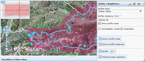
Buffer tool form in WebOffice 10 R3 client
It is possible to specify the Buffer area renderer as well:

Buffer area - Polygon symbology configuration
Property |
Description |
Outline color |
Default Buffer Layer. This Layer gets selected in the Buffer tool form by default. |
Outline type |
Outline type |
Outline width |
Outline width |
Fill color |
Fill color |
Fill type |
Fill type |
Buffer area - Polygon symbology configuration
Buffer area - Polygon symbology in WebOffice 10 R3 client