Manual setup (alternative) |
  
|
Manual setup (alternative) |
|
Notes:
•From WebOffice 10.8 SP1 on, the setup of VertiGIS Printing can be done with an installer. See chapter Installation with Setup.
•When using the VertiGIS Printing with ArcGIS 10.8.1 the installation of Patch ArcGIS Server 10.8.1 Print Service Patch and ArcGIS Server 10.8.1 Print Service and Text Element Patch is necessary!
•To use the VertiGIS Printing tools, at least ArcGIS 10.6.1 is required.
•Directly on the GIS server (where VertiGIS Printing is published) no ArcGIS Pro installation is mandatory. The administration of layouts and publishing of Web Tools can be done from an administration computer.
To set up and use VertiGIS Printing on a server manually (as an alternative to Installation with Setup), the following steps are necessary:
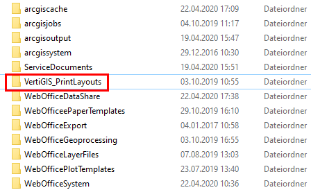
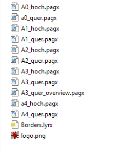
•Navigate to WebOffice10.8-DVD\Software\WebOffice directories\VertiGIS_PrintLayouts and copy the Print Layouts to your server to:
..\arcgisserver\directories\VertiGIS_PrintLayouts
•Create on your ArcGIS Server or Portal for ArcGIS a sub folder named: „VertiGIS_Utilities“
•Register the Layout folder - VertiGIS Print Layouts on your ArcGIS Enterprise. This can be done in ArcGIS Pro or alternatively in ArcGIS Server Manager.
Note: If you do not register the 'VertiGIS Print Layouts' folder, ArcGIS Pro may not publish correctly.
Note: For more details on registering data stores in ArcGIS Pro see ArcGIS online help.
•Navigate to WebOffice10.8-DVD\Software\VertiGIS Utilities\VertiGIS Printing\VertiGIS Printing Toolbox\VertiGISPrintingToolbox.zip and copy the content to your server to: ..\arcgisserver\directories\WebOfficeGeoprocessing\VertiGIS_Utilities. Unzip the file locally and copy the Folder VertiGISPrintingToolbox to \arcgisserver\directories\WebOfficeGeoprocessing\VertiGIS_Utilities.
•Open your ArcGIS Pro installation
•Add the following Toolbox using add Toolbox: ..\arcgisserver\directories\VertiGIS_Utilities\VertiGISPrintingToolbox\VertiGISPrintingTools.pyt
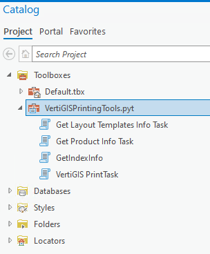
This closed Python Toolbox with the file extension .pyt contains the following tasks:
•Get Layout Templates Info Task
•Get Product Info Task
•GetIndexInfo
•VertiGIS PrintTask
All tasks must be executed first in ArcGIS Pro.
To do this, execute all tasks in ArcGIS Pro (via double-click - please follow the above sequence).
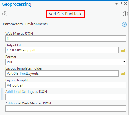
•For the VertiGIS PrintTask please note the following settings:
oFor the Web Map as JSON attribute, enter two brackets -> {}
ofor the attribute Output File, any path/file name can be temporarily selected.
ofor the attribute Format select 'PDF'
oReference the VertiGIS_PrintLayouts Folder (default path: ..\arcgisserver\directories\VertiGIS_PrintLayouts)
oFor Layout Template, select any existing template instead of 'MAP_ONLY'.
Execute the Geoprocessing Task by clicking 'Run'.
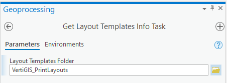
•With the Get Layout Templates Info Task you reference the VertiGIS_PrintLayouts again:
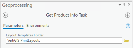
•In the Get Product Info Task, reference the VertiGIS_PrintLayouts again and run the task by clicking "Run":
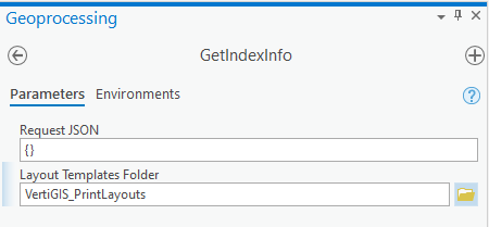
•For the GetIndexInfo Task, at Request JSON enter '{}' again and reference to the VertiGIS_PrintLayouts. Execute the task by clicking 'Run'.
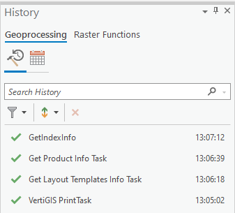
•In the GeoProcessing history, check the successful execution of the scripts:
•If these scripts (tasks) have been run successfully in ArcGIS Pro, the results must be published on your ArcGIS Enterprise:
A) Publish against an ArcGIS Enterprise Portal
B) Publishing against an ArcGIS Server Standalone