Edit Layers |
  
|
Edit Layers |
|
Configure an Edit Layer to fulfill one precondition for providing editing functionality in the WebOffice 10.5 SP2 clients.
Be aware that in order to make editing functionality available in WebOffice 10.5 SP2 you need
•a valid WebOffice 10.5 SP2 advanced license (including the web editing module)
•at least one layer from an ArcSDE geodatabase that is configured as an edit layer
•a configured and activated Editing tool
Note: WebOffice 10.5 SP2 editing is tightly integrated with WebOffice usermanagement. In UserManagement Admin Web you can, e.g. configure a client ID for a user group in order to automatically set the value of the client ID field in the edit layer for this object when the user creates the object. Find more information in chapters WebOffice usermanagement and UserManagement Admin Web.
Note: If you edit into a versioned feature class then WebOffice 10.5 SP2 automatically performs the edits into the version used for the layer in the served ArcMap document. This way edits can be immediately displayed in the map service.
Note: It is possible to edit on a feature class with a different geographic projection then the main map service (the Edit Layer will get reprojected on-the-fly by ArcGIS). Anyway, there may be some precision problems depending on the projection parameters. Therefore, it is recommended to edit on feature classes only that have the same projection like the main map used for display.
Note: Editing features of a layer that has a joined table or layer in ArcMap is supported. However, please consider that the fields of the joined table cannot be used as edit fields.
Note: An easy way to create edit layers is by using the wizard Create Edit Layer.

Edit layers configuration
The edit layer configuration specifies in which way you want to edit on a specific layer of a map service. Therefore, it may contain the subsequent list of child elements:
•Editing Fields specify the attribute fields the user may edit
•List of Lookup Definitions specifies the lookup values visible in the WebOffice 10.5 SP2 clients
•List of Available Edit Actions specifies which edit actions will be available for the user
•Edit User specifies the database user for actually editing the geodata
•Snap Layers specify the available snap layers for this edit layer
•Integrated Editing Application enables users to do attribute edits in an application different from WebOffice 10.5 SP2 clients
•Copy from Layers specifies all layers available in the Copy from edit action to copy objects from a layer to the edit layer
•Layers (with Templates) specifies to control the layers available as template layers for the edit action 'Copy from template'
•Object Assignment Layers specify the layers to be used as source layers for object assignment
•Object Assignment layers (topological) specify the layers to be used as source layers for topological object assignment
•Edit Type defined by feature allows to restrict the editable geometry or attributes by a specific feature field
•GPS Attributes makes it possible to save positioning information via editing
Note: If no Editing fields are configured, then users can change the object geometry only.
Note: In WebOffice 10.5 SP2 it is not necessary to configure editing fields if the fields get edited using an Integrated Editing Application.
Note: If ArcGIS Server Workgroup is used then no edit user can be configured. Instead the corresponding operating system user is used automatically.
Property |
Description |
Layer ID |
Layer ID of the edit layer in the used map service. |
Alias name of edit layer |
Alias name for edit layer (for user interface edit layer drop down list box). |
Usage hint |
Short usage hint that will be displayed in the top right corner. Note: This parameter is WebOffice flex (flash) client specific. |
Feature Layer ID |
Layer ID of the feature layer used for editing. Note: To refer a layer, first a corresponding ArcGIS Server Feature Service has to be configured. Note: Only choose a layer, if editing should be done via Esri FeatureServer Service instead of Server Object Extension. |
Edit mode: •Attributes + Geometry: Attributes and geometry of the object get edited •Attributes: Only attribute data of the object gets edited. The user is not able to change the geometry of the object at all •Geometry: Only geometry of the object gets edited Note: Geometry can be used for example as a construction supply layer. A construction supply layer contains construction supply points and basically must have a Feature class with point geometry as a background. •Attributes + limited Geometry (Split, Multipart explode, Multipart merge): Attribute data of the objects can be edited and a limited support for changing the geometry is allowed (geometry edit actions: split, multipart explode, multipart merge) •Defined by Feature Note: With the WebOffice mobile client, geometry editing is only supported for point feature class (no MultiPoint Features). |
|
Specifies the default edit layer. Note: If multiple edit layers are configured as default edit layer, then the first edit layer in the list is used as default edit layer. |
|
Specifies if the user can edit a created feature directly by a button click (Yes) or not (No, Default). |
|
Map View for edit layer |
Specifies a specific map view/representation model to be displayed when choosing the edit layer. If no map view is configured then the current map does not get changed at all and the map does not get updated when selecting the edit layer. Tip: If you want to assure a specific map view when the user is about to start editing, then use this option. |
External ID |
External ID used in parametrized calls to WebOffice 10.5 SP2 for identifying the edit layer. Note: External layer IDs may not contain spaces or special characters. Only combinations of the following letters and numbers are permitted or are intended to be used: ▪A to Z (uppercase letters) ▪A to z (lowercase letters) ▪0 to 9 (numeric characters) |
Pixel tolerance for vertex selection |
Pixel tolerance for vertex selection controls how sensitive selection of vertex points using the mouse pointer is. If the mouse pointer is within this distance of an object vertex point, then the user is able to select the vertex point. |
Dimensioning |
Support for doing simple dimensioning. Only effects the creation of polylines. If used (Yes) only two-point dimensioning per working step is supported. This also impacts several construction tools. Optionally chain dimensions can be created. |
Use UM editing config? |
If "Yes" is configured, the Editing Configuration for User Management is being used for this edit layer, provided that is has been configured in the application configuration under Common -> User Management. If "No" is configured, the meta data (such as create time stamp, create user, change time stamp, change user) of an edit action are not being saved. Also, the functionality of a "logical delete" is disabled, that means that objects of this layer will be deleted physically. Note: Configuring "No" allows editing on this layer in the case that "Editing configuration for User Management" is present, but the current edit layer does not provide the columns that are necessary to store the meta data. |
Specifies whether editing of object attributes for an object selection (multiple objects) is possible for the user. Editing multiple object attributes at once (one interaction) may increase user efficiency considerably. |
|
Split to segments |
Specifies whether polylines should be automatically split into segments (Yes) or not (No). |
Simple editing having less controls in the edit tool form in the WebOffice 10.5 SP2 client. The following functions are no longer available or restricted: - no 'Vertex Geometry' button - no 'Undo' button ('Reset editing' remains)
|
|
When 'true' is configured the check consistency flag will be evaluated only on edit action 'edit' / 'update' When 'false' is configured the check consistency will also be evaluated on edit action 'create' Note: The edit action 'Copy from' (template and layer) behaves like 'create' |
|
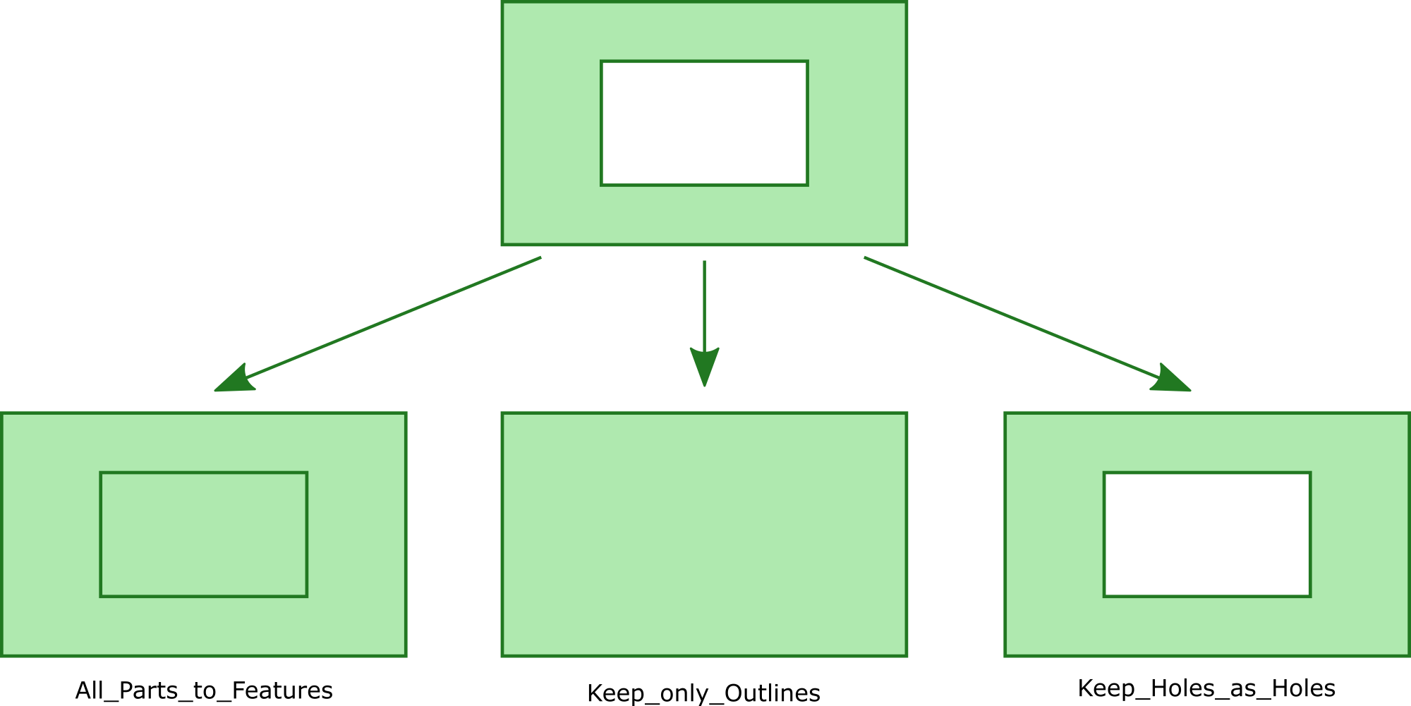
Defines the result of the edit action "Explode Multipart" to the edit layer.
All_Parts_to_Features All parts of multipart-feature become separate Features (even holes)
Keep_only_Outlines Holes as well as islands within holes get removed, only the outermost parts become separate features
Keep_Holes_as_Holes Features containing holes stay multipart-features, islands within such holes however become separate features
Results of the Explode Multipart Modes
Hint: If no Edit fields are configured, users can change the object geometry only. Hint: In WebOffice it is not necessary to configure Edit fields if the fields get edited using an integrated external application. Hint: If ArcGIS Server Workgroup is used, no edit user can be configured. Instead, automatically the corresponding operating system user will be used. Hint: Editing operations will use a feature layer if provided. |
|
Vertex geometry for more than one point? |
The user can have more than one Point in his upload vertex file. These points, when uploaded, will be created for the same set of attributes. This functionality is only used for point layers. |
If activated (true) the merging of objects that are not adjacent is not possible. If deactivated (No) (default value) the contour of the union of the selected objects will be used as resulting geometry in such cases. Note: This setting is only used for the edit action Merge of single part objects. |
|
If activated (true) the Usermanagement Filters will be applied on the value lists in the edit form. The filters are not being applied on the value lists which were defined on a field in the WebOffice author. |
|
Determines whether the end user can move the position of objects during the editing action "Copy from". |
Edit layer properties
Note: See chapter Editing for details about the tool configuration in WebOffice author.
Note: See chapter Editing for details about editing in the WebOffice html client.
Note: See chapter Editing for details about editing in the WebOffice core client.
Note: See chapter Edit Feature for details about editing in the WebOffice mobile client.
Note: See chapter Editing for details about editing in the WebOffice flex (flash) client.