Edit Featuretype (WFS) |
  
|
Edit Featuretype (WFS) |
|
With WebOffice 10.7 SP1 it is also possible to edit features of a transaction WFS (WFS-T). Both the geometry and the attributes of individual features can be edited. Compared to normal basic WFS, this WFS type is characterized by the fact that features can not only be read and queried, but also that write access to the features located in the WFS is made possible.
Make sure that the following requirements are met to enable this editing functionality in WebOffice 10.7 SP1:
▪a valid WebOffice 10.7 SP1 advanced license (with the WebOffice web editing module) must be available
▪the Editing Tool must be configured
▪a working WFS Query on the same topic must exist
▪The WFS must contain the operation Transaction in the GetCapabilities Response.

Example of the transaction operation in the GetCapabilities Response of a WFS-T
GML/3.1.1 is the standard GML version of a WFS version 1.1.0 - which is also supported by WebOffice 10.7 SP1. Based on this, WebOffice 10.7 SP1 supports the following GML geometry types and XML field types for editing fields:
GML geometry types:
•PointPropertyType - point
•MultiLineStringPropertyType - line
•LineStringPropertyType - line
•MultiSurfacePropertyType - polygon
•GeometryPropertyType - polygon
•SurfacePropertyType - polygon
Note: With the GML geometry type GeometryPropertyType, only polygons can currently be edited in the context of WebOffice 10.7 SP1.
XML field types for editing fields:
•string
•int
•integer
•decimal
•float
•double
•date
Note: It is possible to edit features with a different geographic projection from the map service (the editing layer is then dynamically re-projected by ArcGIS). However, depending on the projection parameters, certain precision problems may occur. Therefore it is recommended to edit only features that have the same projection as the displayed main map service.
Note: The Create Edit Layer/Table Wizard does not currently offer a way to create an Edit FeatureType (WFS). This wizard is only used to create an Edit Layer or an Edit Table.
 - Configuration")
EditierFeatureType (WFS) - Configuration
The configuration of an Edit FeatureType (WFS) defines the possibilities for editing in a layer of a transaction WFS. Therefore, the configuration consists of the following list of child elements:
▪The Editing Fields determine which fields the user can edit.
▪The List of Lookup Definitions determines which lookup values are used to display the values to be stored in the database in the WebOffice 10.7 SP1 Client.
▪The List of Available Edit Actions defines the editing actions available to the user.
▪The list of Snap Layers defines those layers whose vertices are available as point snap or line snap when editing the corresponding edit layer.
▪The Integrated Editing Application allows the user to perform attributive editing actions in an application other than the WebOffice 10.7 SP1 client.
▪The entry Object Assignment Layers defines the layers that can be used as the basis for an object assignment.
▪The entry Object Assignment layers (topological) defines the layers that can be used as the basis for a topological object assignment.
▪The Edit Type defined by feature function can be used to restrict the editing function at feature level.
▪With the GPS Attributes, spatial position information can be stored in the editing process.
•GUID field connection
Note: If no editing field is configured, the user can only edit the geometry of an object.
Note: In WebOffice 10.7 SP1 no editing fields need to be configured if the fields are edited with an integrated editing application.
Note: Please note that with WebOffice usermanagement only the access rights for a specific WFS can be defined. If access to a WFS has been blocked, the user group concerned is not able to search or edit the corresponding WFS. Furthermore, it is not possible to restrict individual topics of the WFS via UserManagement Admin Web.
Note: Please note that in the first phase of the WFS-T implementation only the editing actions CREATE, EDIT and DELETE are supported.
Note: Please note that multipart operations are not possible in the first phase of the WFS-T implementation. Multipart features are thus treated as singlepart features.
Property |
Description |
Alias name of edit layer |
Alias name for edit layer (for user interface edit layer drop down list box). |
Usage hint |
Short usage hint that will be displayed in the top right corner. Note: This parameter is WebOffice flex (flash) client specific. |
FeatureType ID |
Layer ID of the edit layer in the used map service. Note: The FeatureTypes that have already been configured for the associated WFS search can be selected from the drop down list box. For more information on configuring a corresponding WFS query, see chapter Create WFS Query |
Edit mode: •Attributes + Geometry: Attributes and geometry of the object get edited •Attributes: Only attribute data of the object gets edited. The user is not able to change the geometry of the object at all •Geometry: Only geometry of the object gets edited •Attributes + limited Geometry (Split, Multipart explode, Multipart merge): Attribute data of the objects can be edited and a limited support for changing the geometry is allowed (geometry edit actions: split, multipart explode, multipart merge) •Defined by Feature Note: Please note that in the first phase of the WFS-T implementation only the editing actions CREATE, EDIT and DELETE are supported. This means that the Attributes + limited Geometry edit mode can only be used to a limited extent. |
|
Specifies the default edit layer. Note: If multiple edit layers are configured as default edit layer, then the first edit layer in the list is used as default edit layer. |
|
Specifies if the user can edit a created feature directly by a button click (Yes) or not (No, Default). |
|
Map View for edit layer |
Specifies a specific map view/representation model to be displayed when choosing the edit layer. If no map view is configured then the current map does not get changed at all and the map does not get updated when selecting the edit layer. Tip: If you want to assure a specific map view when the user is about to start editing, then use this option. |
External ID |
External ID used in parametrized calls to WebOffice 10.7 SP1 for identifying the edit layer. Note: External layer IDs may not contain spaces or special characters. Only combinations of the following letters and numbers are permitted or are intended to be used: ▪A to Z (uppercase letters) ▪A to z (lowercase letters) ▪0 to 9 (numeric characters) |
Pixel tolerance for vertex selection |
Pixel tolerance for vertex selection controls how sensitive selection of vertex points using the mouse pointer is. If the mouse pointer is within this distance of an object vertex point, then the user is able to select the vertex point. |
Dimensioning |
Support for doing simple dimensioning. Only effects the creation of polylines. If used (Yes) only two-point dimensioning per working step is supported. This also impacts several construction tools. Optionally chain dimensions can be created. |
Use UM editing config? |
If "Yes" is configured, the Editing Configuration for User Management is being used for this edit Featuretype (WFS), provided that is has been configured in the application configuration under Common -> User Management. If "No" is configured, the meta data (such as create time stamp, create user, change time stamp, change user) of an edit action are not being saved. Also, the functionality of a "logical delete" is disabled, that means that objects of this layer will be deleted physically. Note: Configuring "No" allows editing on this layer in the case that "Editing configuration for User Management" is present, but the current edit layer does not provide the columns that are necessary to store the meta data. |
Specifies whether editing of object attributes for an object selection (multiple objects) is possible for the user. Editing multiple object attributes at once (one interaction) may increase user efficiency considerably. Note: The selection field in the 'Object key' column of the editing mask always shows the first field of the layer which comes after field 'OBJECTID'. However, the displayed field can be changed to ArcGIS Desktop in the layer properties on the 'Display' tab (display expression). See ArcGIS online help for more details. |
|
Split to segments |
Specifies whether polylines should be automatically split into segments (Yes) or not (No). |
Simple editing having less controls in the edit tool form in the WebOffice 10.7 SP1 client. The following functions are no longer available or restricted: - no 'Vertex Geometry' button - no 'Undo' button ('Reset editing' remains)
|
|
When 'true' is configured the check consistency flag will be evaluated only on edit action 'edit' / 'update' When 'false' is configured the check consistency will also be evaluated on edit action 'create' Note: The edit action 'Copy from' (template and layer) behaves like 'create' |
|
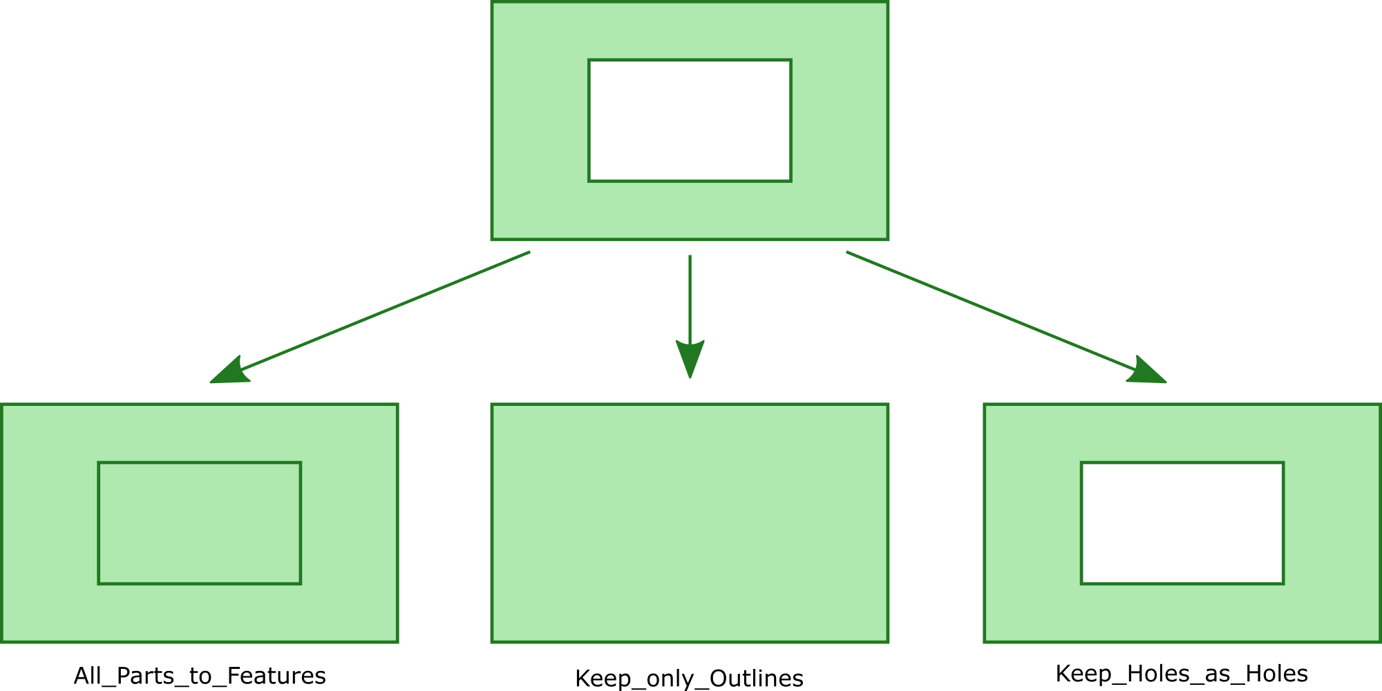
Defines the result of the edit action "Explode Multipart" to the edit layer.
All_Parts_to_Features All parts of multipart-feature become separate Features (even holes)
Keep_only_Outlines Holes as well as islands within holes get removed, only the outermost parts become separate features
Keep_Holes_as_Holes Features containing holes stay multipart-features, islands within such holes however become separate features
Results of the Explode Multipart Modes
Hint: Please note that in the first phase of the WFS-T implementation multipart features will also be interpreted as singlepart features. Hint: If no Edit fields are configured, users can change the object geometry only. Hint: In WebOffice it is not necessary to configure Edit fields if the fields get edited using an integrated external application. Hint: If ArcGIS Server Workgroup is used, no edit user can be configured. Instead, automatically the corresponding operating system user will be used. Hint: Editing operations will use a feature layer if provided. |
|
Vertex geometry for more than one point? |
The user can have more than one Point in his upload vertex file. These points, when uploaded, will be created for the same set of attributes. This functionality is only used for point layers. |
If activated (true) the merging of objects that are not adjacent is not possible. If deactivated (No) (default value) the contour of the union of the selected objects will be used as resulting geometry in such cases. Note: This setting is only used for the edit action Merge of single part objects. Note: Please note that in the first phase of the WFS-T implementation only the editing actions CREATE, EDIT and DELETE are supported. This parameter can therefore be ignored. |
|
If activated (true) the Usermanagement Filters will be applied on the value lists in the edit form. The filters are not being applied on the value lists which were defined on a field in the WebOffice author standalone. |
|
Determines whether the end user can move the position of objects during the editing action "Copy from". |
Edit Featuretype (WFS) Properties
Note: See chapter Editing for tool configuration details in WebOffice author standalone.
Note: See chapter Edit for details on editing in WebOffice core Client.
Note: See chapter Edit Feature for details on editing in <WebOffice mobile Client.
Note: See chapter Editing for details on editing in WebOffice flex (flash) Client.