Add Local Geodata |
  
|
Add Local Geodata |
|
Add local geodata tool in the WebOffice html client
The Add Local Geodata tool enables users to add:
•local vector data
•local raster data
Find more details about the supported formats in the table in the bottom. For users, available formats are listed in the tool dialog of the WebOffice html client. By pressing the ![]() button in Internet Explorer, the Online Help will open and point directly to the "Add local geodata" section. With the use of the F1 button within a textfield of the function the user will get the same help information.
button in Internet Explorer, the Online Help will open and point directly to the "Add local geodata" section. With the use of the F1 button within a textfield of the function the user will get the same help information.
Important Note: The tool Upload Local Geodata can only be used if the dynamic workspaces have been added to the SynOutputService! See chapter Add Dynamic Workspaces to SynOutputService for details.

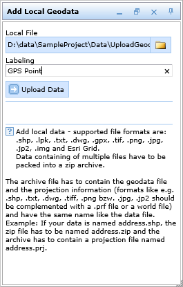
Add local geodata tool form in the WebOffice html client
The uploaded geodata set gets added as layer in the WebOffice 10.5 SP2 table of content. The layer name specified in input field Labeling is used. Symbology of this layer gets dynamically displayed in the table of content.

Add local geodata in the WebOffice html client
Depending on the type of uploaded data (see table in the bottom), the dynamically added layer may be available in the list of selectable/identifiable as well as in the list of snap layers.
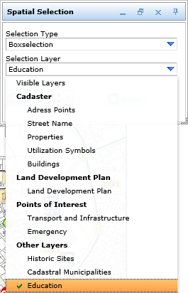
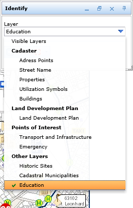
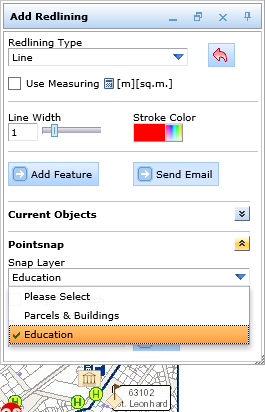
Find uploaded layer in the list of selectable/identifiable/snap layers
The added layer can be removed as well.

Remove uploaded layer from table of content
Upload TXT File
Whenever there is no projection file (PRJ file) in the ZIP file, WebOffice 10.5 SP2 will ask you to set definitions after the data has been uploaded. Keep the default settings for the columns X and Y coordinate.
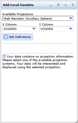
Upload a TXT file and set definitions
Depending on the type of geodata different levels of functionality are available:
Data format |
Data extension |
Available functionality |
Esri Shape |
.shp |
Display, search, select, snap, buffer (the uploaded geodata can be used as source and/or target buffer layer) and copy from layer for editing. |
Esri Layer Package |
.lpk |
Display, search, select, snap, buffer (the uploaded geodata can be used as source and/or target buffer layer) and copy from layer for editing. It is supported to upload layer packages (.lpk) containing more than one layer.
Note: The container file (.lpk) is compressed with the 7z compression mechanism since the introduction of ArcGIS 10.0. the Java-specific Binding Library (sevenzipjbinding.jar) from Sourceforge is applied to extract/unzip the 7z archive files. The sevenzipjbinding-4.65-1.04-rc-extr-only-AllWindows.zip library functions for various process architectures in Windows. The sevenzipjbinding-4.65-1.04-rc-extr-only-AllPlatforms.zip library for the utilization on a Linux server is adequate. Note: Definition queries within a LPK will be added to the query using the AND operator. |
AutoCAD DWG |
.dwg |
Display, search, select, snap, buffer and copy (for editing) are enabled by default. |
Drawing Interchange Format |
.dxf |
Display, search, select, snap, buffer and copy (for editing) are enabled by default. |
TXT |
.txt |
Display, search, select, snap, buffer (the uploaded geodata can be used as source and/or target buffer layer) and copy from layer for editing. Please find a guidance for the upload of a text file in Upload Point Data with Attributes from a Text File. |
GPS eXchange Format |
.gpx |
Display, search, select, snap, buffer (the uploaded geodata can be used as source and/or target buffer layer) and copy from layer for editing. Note: WebOffice 10.5 SP2 supports .gpx files of version 1.0 and 1.1. Way points and routes will get added to the map and table of content at once. Configured styles may be point and line styles; point styles will be available for the way points, line styles for the routes / tracks.
The following result fields can be displayed in the result list of WebOffice html client: •gpx_name (name) •gpx_desc (description) •gpx_elevation (elevation) •gpx_date (recording date) •gpx_time (time of recording) •gpx_lat (Latitute) •gpx_lon (Longitude) |
JPEG Picture |
.jpg |
Display. |
JPEG 2000 Picture |
.jp2 |
Display. |
Portable Network Graphics |
.png |
Display. |
Tagged Image File Format |
.tif |
Display. |
IMAGINE Image |
.img |
Display. |
Esri GRID |
|
Display. |
Add local geodata - supported geodata formats
Note: See chapter Add Dynamic Workspaces to SynOutputService for details about adding dynamic workspaces to the SynOutputService.
Note: See chapter Upload Local Geodata for details about the tool configuration in WebOffice author.