ArcGIS Server Vector Tile Service |
  
|
ArcGIS Server Vector Tile Service |
|
Since WebOffice 10.7 SP1 it is possible to integrate Vector Tile Services into WebOffice flex. In contrast to cached Map Services Vector Tile Services are not based on raster technology, but on vectors. Therefore they are calculated faster and need less disk space.

ArcGIS Vector Tile Service
You can either use your own Vector Tile Services or the ESRI Vector Basemaps in WebOffice 10.7 SP1.
Note: You will find an introduction for publishing Vector Tile Services in ArcGIS online help.
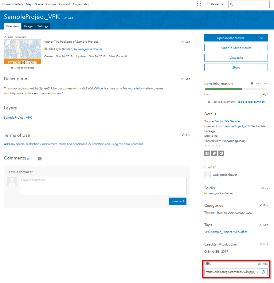
First of all open the distinct Vector Tile Service and copy the URL (see Screenshot below).
Note: Please be aware, that ESRI Vector Basemap 'Styles' can not be handed over to WebOffice yet.
Usage of the URL for WebOffice
Property |
Description |
Server |
ArcGIS Server vector tile service. If the service is secured, the user must log on to the client before using the service (named user). The Vector Tile Server Endpoint URL must be specified.
Note: If you connect to an ArcGIS server or use an ArcGIS online service, make sure that you do not violate Esri Inc. rights of use! |
Service name (GUI) |
Service name of Map Service displayed in the GUI |
Metadata URL |
Configure a reference to a meta data document (must be available via HTTP) as URL. Note: You may configure the unique Metadata document identifier (UUID) of a Catalog Service (CSW 2.0) here. In this case you must configure the SOAP interface of the Catalog Services in Metadata Display. |
Metadata short description |
Provide a short description for the meta data (line breaks with "\n"). |
Copyright |
Service related copyright information that is displayed on the client and on the print. Note: The service-related copyright information is only displayed if the map element Copyright is configured. Note: For more information on how to use this attribute, see Template (File Name) and WebOffice ePaper Template (File Name). |
Service user |
User login for accessing the ArcGIS Online service (ArcGIS service user). |
Password |
Password of user accessing ArcGIS Online service. |
Identify/Select on all visible Feature Layers? |
When using the option All visible Layers in the Client all Layers visible in the current scale and set to visible are taken into consideration. A Layer configuration is not required, the ArcMap Layer Properties get used instead (Layer Name, visible Fields, Field order). |
Server normalized |
Normalized server URL |