Object Assignment layers (topological) |
  
|
Object Assignment layers (topological) |
|
Object Assignment Layers (topological) specifies the layers to be used as source layers for topological object assignment.
")
Configuration - Object Assignment layer (topological)
Property |
Description |
Layer-ID |
Explicit ID of the layer, which will be used for topological object assignment. |
Topological relation |
Defines the required topological relation. Selection: •Single containing feature (Whole feature has to be included) •Single intersecting feature (Intersection possible) •Dominant intersecting feature (In case of intersection, majority of feature has to be included) •No intersection feature (no intersection) •nearest feature |
Assignment required |
Defines whether object assignment is required for editing |
Properties - Object Assignment layer (topological)
Hinweis: It is also possible to configure more than one reference layer. In that case all assigned attribute values will be assumed on the target/edit-layer.
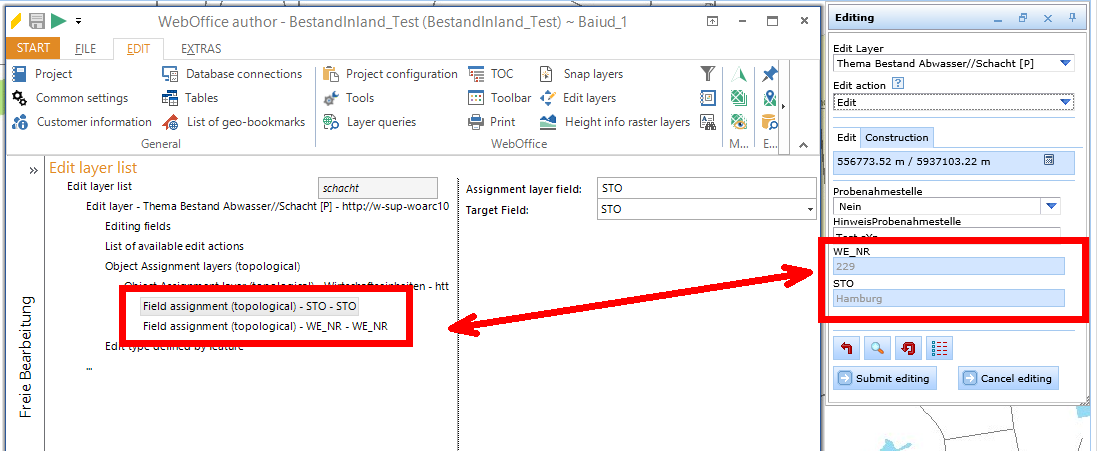
On the reference layer for topological assignment, fields can be coupled together. This specifies the fields to be paired upon object assignment. Thus it is possible to assume the field-values (or angles) from the reference-layer automatically (during an editing operation). Basically it is possible to differ between a simple field assignment 'field -> field' (field values will be assumed) and a field assignment 'angle -> field'. By using the second possibility a specified field will be updated with the angle of the nearest feature (line segment).
field -> field:
, field -> field")
Configuration - Field assignment (topological), field -> field
Properties |
Description |
Assignment layer field |
Fieldname on assigment layer. |
Target Field |
Target inputfield. An existing inputfield configuration is required. |
Properties - Field assignment (topological), field -> field
angle -> field:
, angle-> field")
Configuration - Field assignment (topological), angle-> field
Properties |
Description |
Target Field: |
Target inputfield. An existing inputfield configuration is required. |
Direction measuring system: |
Polar angles are measured counterclockwise from the positive x-axis. In the north azimuth system, the azimuth of a line is the horizontal angle measured from a meridian to the line, measured in the clockwise direction from north. |
Direction measuring unit: |
Unit of angular measure. Supporting only decimal degree (eg 40.251). |
Properties - Field assignment (topological), angle -> field
Note: The fields of the reference-layer (for field assignment) have to be configured also as search- and resultfields on the search-layer.
Note: If you are using a field -> field assignment, the following combinations of datatypes between the appropriate fields of the edit-layer and the reference-layer (for field assignment) are supported:
•BOOLEAN, DATE, NUMBER_FIXED, NUMBER_FLOATING and STRING are compatible with STRING.
•NUMBER_FIXED is compatible with NUMBER_FLOATING.
•OID, INTEGER and SMALL_INTEGER are compatible with each other.
•SINGLE and DOUBLE are compatible with each other.
•BLOB, GEOMETRY and RASTER are compatible with each other.
•STRING, XML, GLOBALID and GUID are compatible with each other.
Note: Please consider, that the length of a field of datatype STRING on the edit-layer must be smaller or equal than the appropriate field-length on the reference-layer (for field assignment).
Note: If you use a 'angle -> field' assignment you have to configure on the assignment layer the topological relation 'nearest feature'.
The linked fields which are filled automatically, will be shown gayed in the editing-dialog (edit actions edit, delete).
Note: See chapter Editing with topological assignment for details about editing in the WebOffice html client.
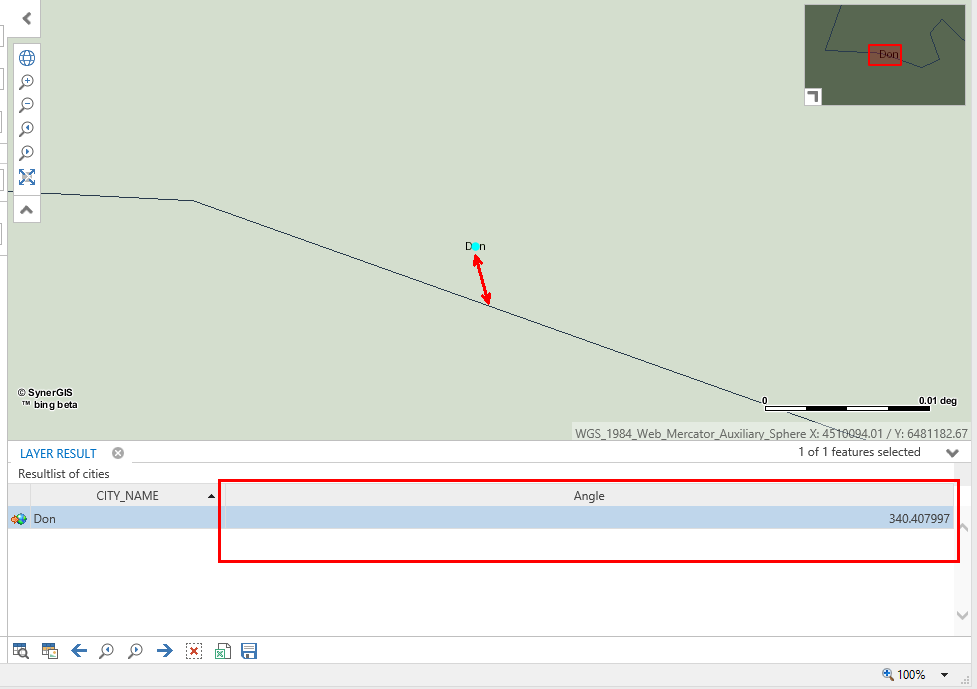
The following image shows a field assignment 'angle -> field', where the point feature (cities) gets the angle from the nearest line feature (rivers).