Spatial Analysis Tools

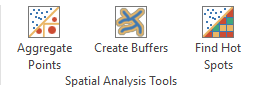
Since ArcGIS version 10.4, the spatial analysis tools can be used in the system dictionary of an ArcGIS Server which is federated with Portal for ArcGIS. These spatial analysis tools contain a variety of geoprocessing tasks. Using WebOffice 10.9 R5, selected tasks can be directly integrated with the WebOffice core client and can accordingly be used in common procedures, e.g. usage based on query results.. The following geoprocessing tasks can be currently used with WebOffice core client:
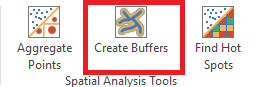
•Create Buffers
This geoprocessing task creates (multiple) polygons which cover a predefined distance starting at a point, line or polygon feature.
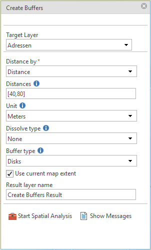
Property |
Description |
Target layer |
Feature with point, line or polygon geometry which is used as the source of the buffer creation. |
Distance by |
Specifies whether a list of distances ('Distance) or the value of a certain field ('Field) is used to create the buffer. |
Distances
Distance field
|
If Distance was chosen in the field Distance by, this field takes the values to create the buffer. This distances have to be written within squared brackets. Multiple Buffer (Creation of multiple buffer circles): [100,200,300] Usage of decimal places: [100.5]
If Field was chosen in the field Distance by, this field specifies which attribute value is taken to create the buffer. |
Unit |
Specifies the linear unit for the distance values. |
Dissolve type |
Determines whether adjacent buffer areas should be overlapping (falsene) or dissolved ('Dissolve). There is also an additional option called Split, which avoids overlapping by delimiting adjacent buffer areas along the imaginary center line of their overlap. Note: Please consider that Split is only available if point geometries are used as target layer. |
Buffer type |
Determines the type of the buffer area. This is especially important for the calculation of multiple buffers. Rings creates separated, non-overlapping rings, while Disks creates overlapping circles. |
sideType |
Determines whether the feature, which is used as the source of the buffer creation, is integrated into the buffer area ('Full) or not ('Outside). Note: Please note that the sideType Outside is only applicable to simple buffers. |
Result layer name |
Defines the name of the result layer, which is also displayed in the Table of Contents. |
Properties of Create Buffers
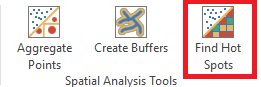
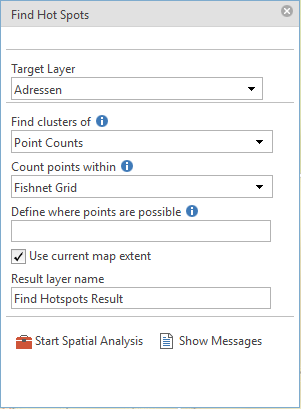
•Find HotSpots
This tool analyses point data to identify statistical significant spatial clusters with high values / densities (Hot Spots) and low values / densities (Cold Spots).
Property |
Description |
Target Layer |
Point or polygon layer which is used as source of the hotspot calculation. |
Find clusters of |
Determines the numeric field in the analyzed target layer. Either a specific field is selected, or the Point Counts mode is used. |
Count points within
|
If the target layer contains points and no specific field was selected via Find clusters of, a polygon layer can be chosen which is used as basis for the aggregation and analysis of the points. All points inside of a polygon feature are summarized to one result value. |
Define where points are possible |
If the target layer contains points and no specific field was selected via Find clusters of, a polygon layer can be chosen where events are possible. All points, which are not inside this polygons, are ignored. |
Result layer name |
Defines the name of the result layer, which is also displayed in the Table of Contents. |
Properties of Find HotSpots
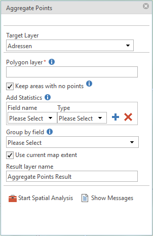
•Aggregate Points
This tool works with point and polygon features and calculates, which points are contained by which polygons. The result can be used for further, field specific statistics.
Property |
Description |
Target Layer |
Point features, which are aggregated within a specific polygon. |
Polygon Layer |
Polygon layer in which the point features are aggregated. |
Keep areas with no points
|
Specifies whether polygons, which contain no points, are returned. |
Add Statistics |
Further field specific statistical analyses can be determined for all points inside a polygon. The following statistics are provided:
•Sum - Calculates the total value of all points inside every polygon. •Mean - Calculates the mean value of all points inside every polygon. •Min - Returns the smallest value of all points inside every polygon. •Max - Returns the largest value of all points inside every polygon. •Stddev - Returns the standard deviation of all points inside every polygon. |
Group by field |
Specifies the field name of the point layer, which is used to group the points. |
Result layer name |
Defines the name of the result layer, which is also displayed in the Table of Contents. |
Properties of Aggregate Points
Note: If you use the spatial analysis tools based on a query result, only the selected objects are used for the analysis. If the spatial analysis tools are opened via the toolbox, the spatial analysis is based on all objects of the target layer.
Note: For details about the configuration of this tools, see chapter Spatial Analysis.
Note: For details about the configuration of this tools in query results, see chapter Spatial Analysis Tools.